
You're looking at a deed, listing sheet, or appraisal notice that says 0.85 acres, 2.50 acres, or perhaps 5.3 acres, and the figure feels abstract. How much land is that in your yard, pasture, or proposed building site? The answer starts with the textbook measurement of an acre, but it can't end there. Shape, access, easements, land use, and the county appraisal record can all change what that acreage means in practice.
For a Texas property owner, getting the number right can affect tax valuation, exemption eligibility, buildable area, and resale decisions. A map may show one boundary, a deed may describe another, and an appraisal record may divide the parcel into several land-use categories. The goal is to reconcile those records before a small-looking discrepancy becomes an expensive assumption.
What an Acre Actually Looks Like on the Ground
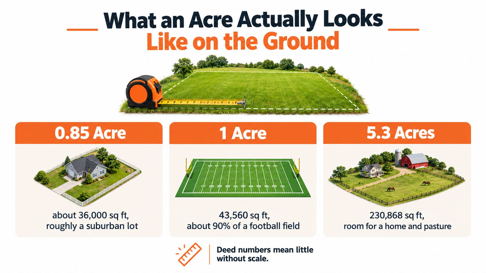
A homeowner comparing properties outside Austin may see 0.85 acres on one listing and wonder whether that means a slightly larger suburban lot or a long, awkward strip behind a house. A landlord evaluating land for a duplex may see the same number and focus on parking and setbacks. A rural owner checking a pasture tract may care more about fencing, access, and usable ground than the total area printed on the notice.
Those owners are all asking the same basic question: what does the acreage look like in real life? An acre is large enough to matter, but the number alone doesn't tell you whether the land forms a practical building site. A compact parcel may provide useful frontage and a straightforward building footprint, while an acre wrapped around a creek or constrained by an easement may offer much less usable space.
Quick Visual Reference for an Acre
| Shape | Dimensions | Square Feet |
|---|---|---|
| Square acre | Approximately 208.71 ft by 208.71 ft | 43,560 |
| Rectangular acre | 100 ft by 435.6 ft | 43,560 |
| Long, narrow acre | 50 ft by 871.2 ft | 43,560 |
That table illustrates the central idea. The area stays constant, but the experience of owning the land changes. A square configuration may be easier to fence and develop. A narrow configuration may have limited access or frontage even though the recorded acreage is identical.
A property owner reviewing photographs, plats, or aerial images may benefit from a specialized visual resource such as real estate media for The Acreage, especially when trying to communicate the relationship between land, structures, and surrounding features. Visual context can't replace a survey, but it can make an acreage figure easier to understand.
The number also carries financial consequences. If land is valued by square foot, a mismatch between recorded acreage and actual parcel area can affect the calculation. If an exemption depends on agricultural or wildlife use, classification and usable land may matter more than gross acreage. “Close enough” isn't a reliable standard when the same figure appears in tax, legal, and resale records.
The Fixed Definition and Essential Unit Conversions
An acre is an exact area unit, not an approximate description of a typical lot. Under the modern international-foot definition, one acre equals exactly 43,560 square feet, 160 square rods, or 10 square chains. It also equals 4,046.8564224 square meters or 0.40468564224 hectare, as documented by the National Institute of Standards and Technology's revised unit conversion factors.
For most property reviews, square feet are the most useful working unit. Use these two rules:
- Square feet to acres: divide the square-foot total by 43,560.
- Acres to square feet: multiply the acreage by 43,560.
Suppose a parcel contains 87,120 square feet. Dividing that figure by 43,560 gives 2 acres. In the other direction, a 2.50-acre tract should contain 108,900 square feet, because 2.50 multiplied by 43,560 equals 108,900.
That conversion gives you a practical audit method. Take the acreage shown on the deed or appraisal record, convert it to square feet, and compare the result with the survey, GIS measurement, and any appraisal calculation that uses a square-foot rate.
Useful Conversion Examples
| Recorded area | Equivalent area |
|---|---|
| 1 acre | 43,560 square feet |
| 2.50 acres | 108,900 square feet |
| 1 acre | 4,046.8564224 square meters |
| 1 acre | 0.40468564224 hectare |
For a homeowner planning turf or landscaping, the same conversion can help define the area before reviewing a lawn installation cost guide for homeowners. The land calculation comes first. Pricing, materials, and site preparation depend on the area that will be treated, not merely the acreage of the entire parcel.
Why Foot Definitions Can Matter
Older surveys and records may use the U.S. survey foot, while modern conversions often use the international foot. The distinction is very small, but it can explain a minor discrepancy when an older Texas survey, a modern GIS system, and a current appraisal record don't produce precisely identical results.
That small unit issue shouldn't distract from larger questions. A conversion can confirm the mathematics, but it can't confirm that the map follows the correct legal boundary or that the county assigned the right land-use category. Use the formula to test the record, then investigate the boundary and classification when the figures don't reconcile.
Why Shape Changes Everything an Acre Can Be
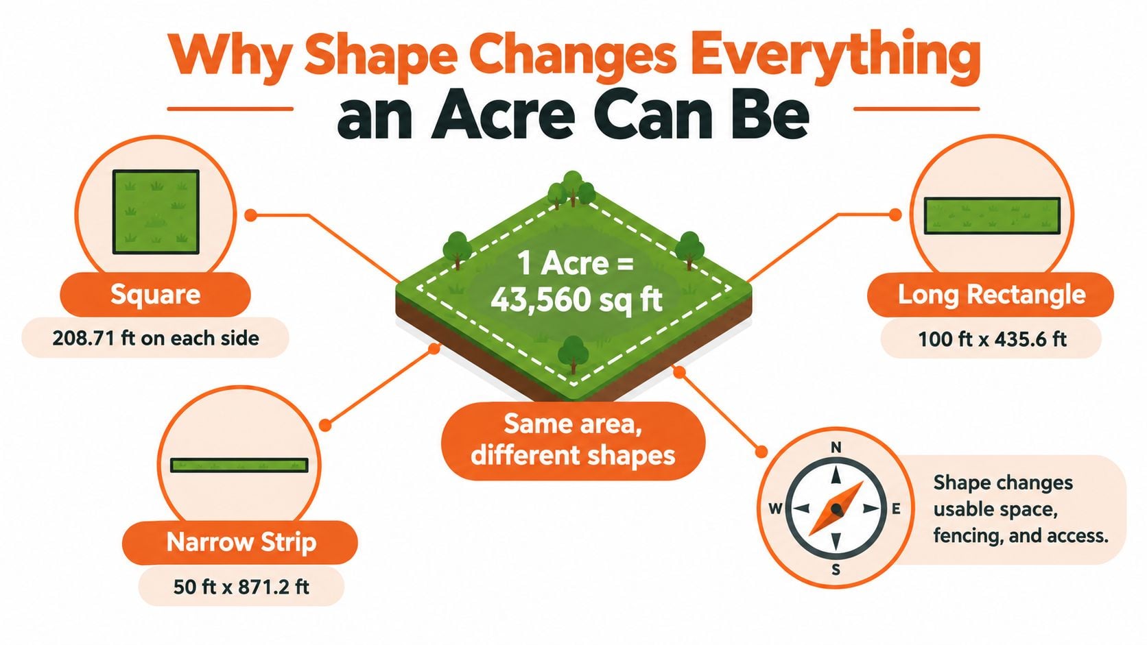
Two parcels can contain the same area and function as completely different properties. A square acre is approximately 208.71 feet on each side. A rectangular acre could measure 100 feet by 435.6 feet, while a narrow strip could measure 50 feet by 871.2 feet. Each configuration contains 43,560 square feet, but a buyer, builder, or appraiser won't experience them in the same way.
Three Parcels With One Area
A compact square may offer a balanced building footprint, convenient fencing, and access from a public road. The rectangular parcel might provide excellent frontage but leave a long rear section that is harder to serve with utilities. The narrow strip could contain the correct acreage while making parking, driveway placement, setbacks, and emergency access difficult.
Irregular parcels create a different challenge. A boundary may follow a creek, tree line, road curve, or floodplain. The legal area can still be accurate, but portions of the parcel may be difficult or impossible to use for a home, commercial structure, driveway, septic system, or pasture operation.
Practical rule: Treat acreage as an area measurement first, then examine the geometry that creates it.
Easements can further reduce practical utility. A utility easement, access easement, drainage corridor, or shared driveway may remain part of the recorded parcel while restricting what the owner can build or alter. Frontage also matters. Two one-acre parcels may have different market utility if one touches a suitable public road and the other depends on a constrained access route.
Gross Area Is Not Always Usable Area
A deed may report the gross area inside the legal boundary. A site plan may focus on buildable area. An appraisal record may divide the land according to use. A GIS viewer may display a parcel polygon that helps with orientation but doesn't establish every legal limitation.
Those aren't necessarily contradictions. They're different descriptions of the same property for different purposes. Area tells you how much land exists. Shape and constraints help determine what that land can do. That distinction is why a parcel with identical acreage to a neighbor can carry a different tax value, selling price, or development outlook.
Practical Ways to Measure an Acre Yourself
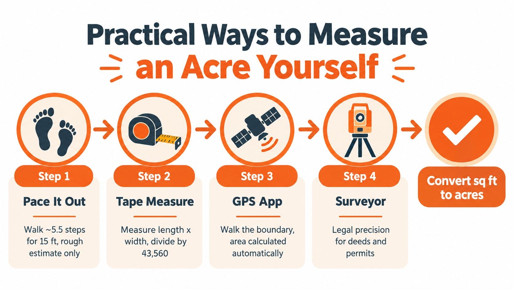
Start with the least complicated method that answers your question. If you only need a rough sense of whether a backyard, field, or visible rectangle is close to an acre, pacing, a tape measure, or a measuring wheel may be enough. These methods become unreliable when vegetation, slopes, fences, irregular boundaries, or inaccessible corners interfere.
For a simple rectangle, measure the length and width, multiply them to obtain square feet, and divide by 43,560. For an irregular area, break the parcel into manageable shapes and total the results, but treat the outcome as an estimate unless the boundary is known and the measurements are dependable.
A Practical Measurement Ladder
Pace the area for orientation. Walking the boundary can help you understand scale and identify obvious differences between the recorded description and the ground. Pacing is a rough estimate, not a boundary determination.
Use a tape or wheel on accessible land. This works best for small, visible sections with clear corners. Record each measurement and sketch the shape instead of relying on memory.
Check a phone app or Google Earth. Consumer area tools can provide a useful first sanity check. Trace the apparent boundary, save the result, and compare it with the recorded acreage.
Review the county GIS parcel viewer. GIS layers can help you compare the appraisal district's parcel outline with an aerial image, deed description, or survey. They should support review, not replace legal evidence.
Hire a licensed surveyor when the boundary matters. A survey is appropriate for conveyance questions, boundary disputes, construction decisions, and disagreements involving a deed or recorded plat.
Modern equipment can make preliminary measurement far more precise. Technical material from the Texas Society of Professional Surveyors reports centimeter-level performance from combinations of GNSS, remote sensing, drones, and LiDAR, with some LiDAR systems achieving approximately 1 to 3 centimeters of horizontal accuracy under suitable conditions.
That precision still doesn't give an aerial model legal authority. A drone or LiDAR system can measure the wrong fence line with impressive accuracy, omit an easement, or follow a visible feature that doesn't match the deed. A useful homeowners guide to land surveys can help explain why boundary evidence and professional standards matter beyond the output of an app.
The following video can provide additional visual context for land measurement techniques:
Use calculators and GIS for screening. Commission a survey for a boundary, conveyance, construction, or exemption dispute. Then compare the result with the county appraisal record before filing a protest, signing a contract, or assuming that a tax calculation is wrong.
How Texas Appraisal Rules Treat Acreage by Land Use
Texas appraisal records don't always treat a rural parcel as one undifferentiated block of land. The rules require rural and acreage parcel records to show parcel size and acreage by use category, including irrigated land, cropland, pasture, orchard, timber, and barren or waste land, as described in the Texas appraisal rule for acreage parcel records.
That classification matters because land-use categories can support different appraisal treatments. An acreage figure on a notice may therefore represent more than a geometric calculation. It can reflect how the appraisal district identified and assigned portions of the parcel.
Read the Record as a Land-Use Map
A rural owner should ask several questions when reviewing the record:
- Is the entire parcel assigned to one use, or is it divided among multiple categories?
- Does the listed pasture, cropland, timber, orchard, or waste area match conditions on the ground?
- Are roads, ponds, slopes, floodplain areas, and other constrained sections represented accurately?
- Does the current use support the exemption or appraisal treatment being claimed?
The Texas Comptroller states that ownership maps combined with detailed soil-survey information are the most accurate way to determine acreage by land class on an individual parcel. That guidance is especially useful when a parcel contains mixed terrain or when a general aerial image doesn't reveal soil or agricultural distinctions.
Wildlife-management open-space appraisal creates another point of confusion. Texas guidance says there is no statewide minimum acreage for wildlife-management open-space appraisal, although local minimums may apply in some circumstances. Changes in tract acreage and local requirements can affect the analysis, so an owner shouldn't assume that a size threshold alone answers the eligibility question.
For owners reviewing agricultural treatment, INTELLI's ag exemption requirements can serve as a starting point for organizing the relevant property and use information. The practical lesson is simple: a tax notice contains classification decisions as well as area figures. If the land-use assignment is wrong, correcting the acreage alone may not resolve the valuation.
Where Acreage Errors Quietly Inflate a Tax Bill
Acreage errors often begin with an ordinary record change. An inherited tract may have been split without every related record being updated. A GIS overlay may include a road sliver or a neighboring section. A land-use category may remain unchanged after the property stops operating in the way the record describes.
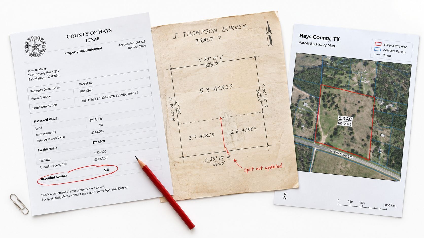
Four Quiet Failure Points
- Unupdated parcel splits: A deed and appraisal record may not describe the same post-split configuration.
- Boundary overlay errors: A digital layer can appear to include land that belongs to a road, adjacent tract, or separate legal parcel.
- Stale land-use coding: The record may classify land as pasture, timber, or another use that no longer matches actual conditions.
- Unclaimed exemptions: Eligible Homestead, agricultural, or other exemptions may not appear because the owner never applied or the record was not updated.
Each problem can produce a different tax consequence. An overstated area may support a higher valuation. A misclassified use may prevent the owner from receiving the applicable treatment. An omitted exemption can leave the taxable value higher even when the parcel geometry is correct.
For Austin and greater Texas properties, INTELLI's data-first review process uses public and private records to compare the appraisal record with available property evidence. The work is recurring and practical, not limited to unusual disputes. A boundary comparison, land-use review, and exemption check can reveal why a figure that looks ordinary on a notice doesn't match the property the owner controls.
A useful technical reference for understanding the boundary concept is baseline in surveying, particularly when a reviewer must distinguish a measured line from the legal evidence that establishes a parcel.
Why Licensed Local Expertise Closes the Loop
Measurement is necessary, but it isn't enough to win a property-tax review. A protest may require the right comparable properties, evidence that the assessor's model relies on flawed assumptions, and arguments adapted to local appraisal district practices and hearing conditions.
An online acreage calculator can identify a mathematical mismatch. It can't decide whether the mismatch comes from a deed, a survey, an easement, a land-use classification, or an appraisal data-entry problem. It also can't select the strongest valuation evidence or present a defensible argument before a county appraisal district.
INTELLI uses licensed property tax consultants and a data-first approach that combines public and private data. Its consultants can use acreage analysis as one part of a broader review involving valuation evidence, exemptions, parcel records, and, where appropriate, a tax recovery audit. The service uses a risk-free, results-based model, so the owner can request an evaluation without treating the professional review as a speculative expense.
INTELLI reports average reductions of about 15 percent in its publisher information, with the explanation of why a licensed local property tax consultant still matters providing further context. The publisher information also states that there is no upfront cost. Those terms can make a professional review practical when the acreage figure, land-use category, or exemption record doesn't line up.
A Working Checklist Before You Pay the Bill
Before paying a tax bill, signing a purchase contract, or filing a protest, work through this checklist:
- Confirm acreage: Compare the deed, survey, and GIS parcel layer.
- Check actual use: Match the land on the ground with the appraisal record's categories.
- Review exemptions: Verify Homestead, Over-65, Disabled Person, Disabled Veteran, agricultural, and historic exemptions.
- Flag constraints: Note frontage, easements, floodplain areas, and unusable portions.
- Request a review: Get licensed guidance when records conflict instead of guessing.
Measuring an acre correctly is one of the most impactful steps a Texas property owner can take. The same number can influence valuation, exemption decisions, and resale discussions for years.
INTELLI helps Texas homeowners, investors, landlords, and commercial owners review acreage, appraisal records, exemptions, and valuation evidence through a data-first process using public and private data. Visit INTELLI to request a professional property-tax review when your deed, survey, GIS map, or appraisal record doesn't align.