
You're looking at a property with enough land for an addition, another rental unit, or a larger parking area. Then the survey shows a restricted strip along the creek or the rear boundary. You still own that land, but your plans may not fit on the part you're allowed to develop.
A buffer zone in real estate can change a property's practical usefulness without changing its advertised acreage. The important questions are where the restriction starts, what activities it prohibits, and whether it affects what buyers would pay. That last connection matters especially when you're deciding whether the property's tax appraisal is too high.
What a Buffer Zone Is and the Main Types
A buffer zone is a strip of land where building, grading, or clearing is restricted, usually to separate development from a street, water, a neighboring use, or a sensitive feature. Think of it as a no-build margin around a playing field, not a fence that takes the field away from its owner.
The owner generally keeps title. What changes is the right to use the affected strip. Some restrictions address structures alone; others also limit paving, vegetation removal, excavation, or storage.
Main buffer zone types and who sets them
| Buffer type | What it protects | Measured from | Usually set by |
|---|---|---|---|
| Zoning setback | Street frontage and neighboring lots | Property line or street line | City or county zoning code |
| Floodplain or floodway setback | Flood-prone land and structures | Floodway or mapped flood boundary | FEMA flood maps and local floodplain rules |
| Wetland or stream buffer | Water quality and habitat | Top of bank, ordinary high-water mark or wetland edge | Local critical-area or watershed ordinance |
| Coastal or shoreline setback | Dunes, tidal lines and erosion | Tidal baseline or dune line | State coastal program and local code |
| Conservation or easement buffer | Protected vegetation and open space | Recorded easement boundary | Deed, plat or conservation agreement |
FEMA maps help identify flood hazards, but the applicable local regulation establishes the development restriction. Likewise, a recorded easement is a different legal instrument from a zoning ordinance.
The Georgetown Climate Center's explanation of setbacks and buffers distinguishes setbacks that separate structures from hazard baselines from buffers that preserve undeveloped land's natural functions. Private restrictions require a separate review; understanding what a covenant in real estate means helps distinguish recorded obligations from public land-use rules.
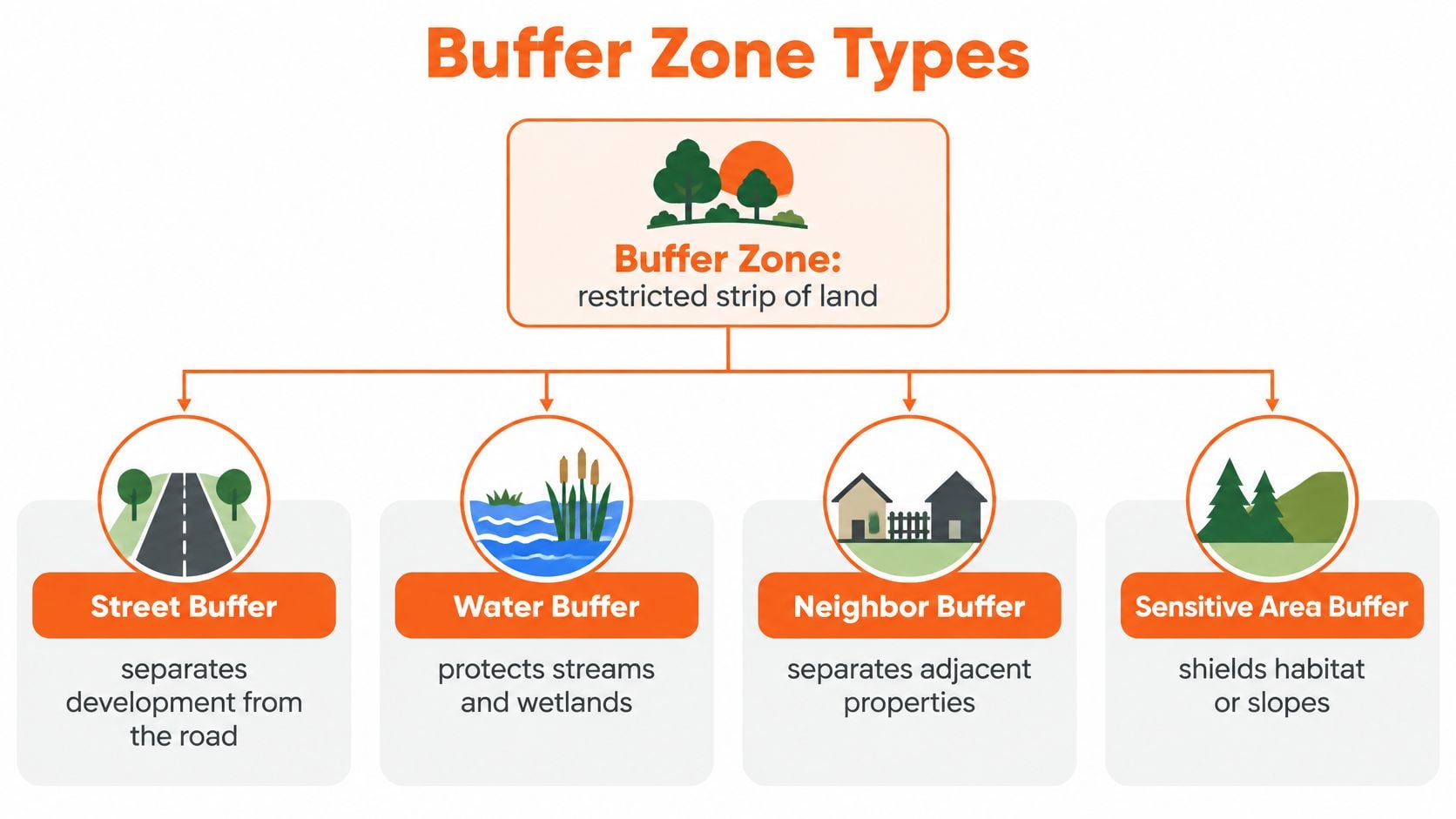
The diagram groups these restrictions by what they separate or protect.
A regulated area isn't always the buffer
Maryland illustrates why terminology matters. The General Assembly established the Chesapeake Bay Critical Area Program in 1984, covering land within 1,000 feet of the specified tidal-water, tidal-wetland, and tributary boundaries, while the strictest zone is generally a minimum 100-foot vegetated buffer measured inland, according to Worcester County's program overview. New development in that buffer is generally prohibited unless an applicable exception or variance allows it.
The broader regulated area and the narrower buffer aren't interchangeable. A waterfront owner may retain the entire lot while facing substantial limits on where development can occur.
Setback-style controls also predate modern environmental law: a 1799 Hartford, Connecticut, ordinance established a street-related building line, as documented in historical zoning literature.
Identify the type before interpreting the distance. A parcel can carry overlapping public and private restrictions, each with a different purpose and measurement point.
Buffer Widths by Location and Neighboring Use
A parcel beside a busy road may have a front setback, while one near a stream may have limits on clearing and grading. There is no universal buffer width: the distance depends on the rule, the protected feature, and the neighboring use.
The examples below show how widths vary. Use them to frame questions about a property, not to set a project's limits. The applicable ordinance, recorded restriction, or agency determination must match the parcel and proposed use.
Typical buffer widths by context
| Context | Typical width | Source basis |
|---|---|---|
| Newburgh, NY: several nonresidential uses, including facilities with 400 to 500 parking spaces | 85 feet | Newburgh's published zoning requirements |
| Newburgh, NY: heavy industrial uses, truck terminals, buildings over 50,000 square feet | 100 feet | Newburgh's published zoning requirements |
| Chesapeake Bay Critical Area, Maryland: tidal waters and tributary streams | Generally 100 feet vegetated, measured inland | Worcester County's Chesapeake Bay Critical Area overview |
| FEMA guidance: streams, wetlands and floodways | Common 25 or 100 feet | FEMA floodplain-management guidance |
| Texas coastal and watershed guidance: waterbodies | Minimum 25 feet undisturbed | Texas planning guidance |
| Texas streams draining at least 320 acres | 50 feet from top of bank on each side, or wider 100-year floodplain | Texas watershed guidance |
| Historic street-line setback example: detached single-family homes | 35 feet from street line | Historical zoning literature |
Newburgh's ordinance ties separation distances to neighboring use. It distinguishes facilities such as hospitals, nursing homes, and some parking-intensive uses from heavy industrial operations, truck terminals, and outdoor storage. Where competing buffer standards apply, the ordinance generally uses the larger width.
A change in intended use can therefore change the applicable requirement. A parcel suited to its current operation may not fit a proposal involving more parking, outdoor activity, or a different use classification.
Practical rule: Identify the applicable use category before settling on a width.
Read the measurement language closely
A vegetated strip and a building setback may cover the same ground but restrict different activities. A building might sit outside a restricted area while paving or clearing within it remains prohibited.
For Texas properties, distinguish planning recommendations from adopted, enforceable requirements. Guidance may inform site design without establishing the restriction that applies to a particular parcel.
The historic street-line example shows that a familiar front yard can function as a regulated setback. Its effect on where a building can go may resemble an environmental buffer, though the permitted activities can differ.
Before relying on a listed width, confirm:
- The applicable category: Match the existing and proposed uses to the ordinance.
- The starting line: Determine whether measurement begins at a property boundary, bank, wetland edge, or another reference point.
- The restricted activities: Check buildings, paving, grading, clearing, and accessory improvements separately.
- The overlap rule: Find out whether the larger restriction controls or whether an additional setback applies beyond it.
How to Locate the Buffer on Your Parcel
A useful buffer map starts with legal boundaries and ends with a defensible building envelope. Measuring backward from visible water or copying a shaded online map isn't enough.
FEMA's floodplain-management guidance describes common 25- or 100-foot setbacks where clearing, grading, or alteration may be prohibited. The associated Texas planning guidance recommends a minimum 25-foot undisturbed vegetative buffer for waterbodies and identifies 50 feet from the top of bank on each side for streams draining at least 320 acres, or the 100-year floodplain when wider.
Build the map from the correct reference line
Pull the recorded survey or plat. Confirm the lot's legal description and boundaries before plotting development limits. Dollar Land Store's boundary advice for first-time acreage buyers is a useful introduction to why listing photos and tax-map outlines aren't substitutes for a survey.
Find the reference point named in the rule, such as the top of bank, ordinary high-water mark, wetland boundary, or floodway line. Ask a qualified professional to locate an uncertain environmental boundary rather than measuring from today's visible water edge.
Check the FEMA flood map and request a flood-zone determination. Use the result to investigate applicable local floodplain requirements. Being outside a mapped flood zone doesn't establish that every stream, drainage, or environmental setback is absent.
Open the city or county's zoning, watershed, and critical-area overlays for the address. Base zoning alone may describe permitted uses without showing the environmental restrictions that affect construction.
Read the deed, plat notes, and recorded easements. Look for drainage, conservation, access, and other private restrictions. Municipal approval doesn't automatically release a separate recorded obligation.
Resolve the overlap between environmental buffers and ordinary setbacks. Confirm whether the larger distance governs or whether a building setback must be measured beyond the environmental buffer; don't choose the smaller distance.
Calculate the usable envelope. Plot all applicable restrictions, account for overlapping areas without subtracting them twice, and identify the remaining connected space. A leftover area that can't accommodate access or the proposed building isn't a workable development envelope.
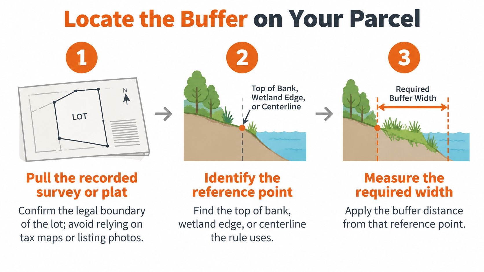
The simplified process below highlights the core mapping sequence.
Specify the finished deliverable
Ask for a sketch showing the reference line, buffer edge, setback edge, and usable area in square feet. Include the governing document and any unresolved boundary or permitting issue.
Survey terminology can cause confusion here. Understanding a base line in surveying helps explain how survey measurements are organized, but the environmental ordinance may specify a different feature as the buffer's starting point.
Treat GIS layers as screening tools. Use the recorded survey, any required environmental delineation, and the responsible authority's written determination to resolve the project's actual limits.
A precise distance measured from the wrong line still produces the wrong building envelope.
How Buffers Shrink Usable Land and Value
Gross lot area describes the parcel's total size. The legally usable envelope describes where a proposed improvement can fit after applicable restrictions are mapped.
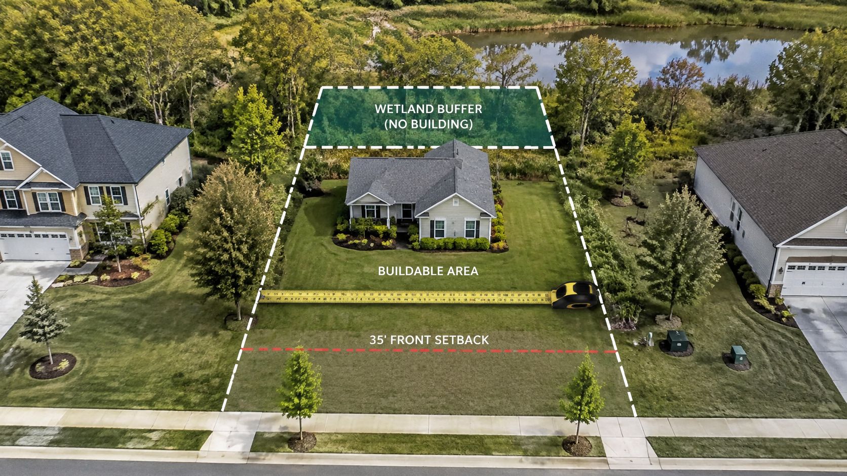
Consider a shallow lot with a front setback and a wetland buffer along the rear. Even if the middle remains open, its shape may prevent a practical building layout, driveway connection, or parking arrangement. The problem isn't how much land remains; it's whether that land supports the intended use.
This layout illustrates the difference between the property boundary and the development envelope.
Test the layout rather than subtracting acreage alone
For a clearly hypothetical comparison, suppose a 50-foot environmental buffer and a 20-foot zoning setback extend from the same reference line. Where the larger-distance rule applies, the governing limit is the environmental buffer, not the smaller zoning setback.
Don't assume those distances always combine by addition, either. Their relationship depends on the measurement origins and the applicable code.
Kitsap County's residential setback guidance explains that a larger critical-area buffer can supersede the ordinary zoning setback and that an additional building setback may be required beyond the buffer for features such as wetlands or steep slopes. A developer who plots only the property-line setback can therefore overstate the achievable layout.
A feasibility file should document:
- Gross and legally usable acreage: Keep the parcel total separate from the development envelope.
- Building footprint: Test the proposed structure within all governing limits.
- Impervious surface: Include paving and other regulated coverage, not just the roof.
- Parking and access: Show workable circulation and connections.
- Clearing limits: Identify vegetation that must remain and areas where construction disturbance is restricted.
Preserved land can also provide value
A buffer isn't automatically worthless land. Preserved vegetation may provide privacy, an attractive outlook, erosion control, or stormwater benefits that buyers value.
EPA guidance summarizing wetland-buffer studies reports approximately 65–75% nitrogen-removal efficiency for 15-meter buffers and roughly 80–90% for 30-meter buffers, with performance affected by flow conditions and site characteristics. Those findings explain environmental function, not a guaranteed performance level for an individual backyard.
The appropriate valuation question is therefore what buyers gain and lose, not whether every restricted square foot has no value. A homeowner may appreciate preserved woodland while a rental investor places more weight on whether another income-producing improvement is permissible.
For owners comparing valuation approaches across markets, Christie's valuation for Puerto Rico homes offers a residential valuation resource. Any conclusion about a restricted parcel still needs local comparable sales and its actual development rights.
The accompanying video offers another visual reference for considering the property layout.
Before acquisition, test the highest and best use against the constrained layout. A proposed addition that doesn't fit, a parking arrangement that can't be approved, or an access route that requires prohibited disturbance should affect feasibility before it becomes an assumed source of value.
Why a Buffer Does Not Automatically Lower Your Tax Bill
A parcel can contain substantial acreage and still offer limited space for construction. That difference matters to a buyer, but it does not automatically change the property's taxable value. Appraisers consider the property as a whole, including its improvements, permitted uses, easements, comparable sales, and buyer demand.
A buffer may have little effect on an existing home that fits comfortably within the permitted building area. It may matter more when the property's price depends on redevelopment. The case for a lower valuation needs to connect the restriction to a measurable effect on what buyers would pay.
Countywide movement doesn't prove parcel-level value
Travis County's published FY 2026 estimate projects an average taxable homestead value of $515,213, up 2.24%, while projecting the median to fall 1.51% to $391,064. These figures move in different directions, showing why a countywide trend cannot establish whether a particular constrained property is overvalued.
A tax bill and an appraisal are related, but they answer different questions. To understand the valuation at issue, start with the components of the property tax assessment, then identify which conclusion you believe does not reflect the parcel's characteristics or market position. A complaint about the tax rate, by itself, does not show that the property's appraised value is wrong.
For an appeal: Show the restriction, its practical consequence, and why a buyer would pay less because of it.
Turn the restriction into valuation evidence
Build a clear chain from the site condition to its effect on market value:
- Restricted-area map: Mark the affected portion and the legally established reference line.
- Permitted-use documentation: Show what can still be built or operated, including applicable approvals.
- Comparable sales: Use properties with similar constraints where possible. Explain meaningful differences rather than treating unrestricted parcels as identical.
- Development-cost evidence: Document necessary redesign, access changes, or site-work consequences.
- Income effects: Support any lost rental or commercial potential with a feasible alternative layout and credible income evidence.
Keep the argument tied to what is legally and physically possible. A hypothetical project that could not be built does not establish lost value. Nor does every dollar of added construction cost necessarily reduce market value by the same amount. Buyers may weigh those costs differently depending on demand and their alternatives.
The Texas Comptroller's property-tax reports and datasets include benchmarks such as ratio studies of appraisal uniformity and median appraisal levels within major property categories. These can help put an appraisal in context, while the parcel-specific evidence explains how its buffer affects its market value.
INTELLI uses a proprietary, data-driven system to prepare evidence challenging inflated valuations and represents clients before county appraisal districts. For a constrained property, the key is to connect the documented restriction and site limitations to relevant valuation evidence, rather than treating unusable acreage alone as proof of overassessment.
A buffer does not guarantee a tax reduction. A persuasive case shows why the existing appraisal does not reflect what informed buyers could do with the property.
Decide Before You Buy or Appeal
A parcel's recorded acreage can look generous on paper, yet a buffer may leave too little usable space for the project you have in mind. Before buying, assess what can legally and practically be built. Before appealing, determine whether the restriction affects the property's supported market value.
Use a buy-or-appeal decision sequence
Resolve uncertain boundaries before committing. Ask the surveyor and responsible authority to reconcile recorded boundaries, environmental delineations, and municipal requirements. If they disagree, don't base your purchase assumptions on disputed development potential.
Compare the confirmed buildable area with your actual project. Have a designer or land-use professional assess the building, parking, access, and necessary site disturbance together. A layout that fits on paper may still fail when those elements are considered as a whole.
Identify the economic effect. Does the buffer change permitted use, achievable lot yield, operating income, or likely resale demand? If your intended use still works, the restriction may be manageable rather than a reason to walk away.
For an appraisal challenge, organize site and market documents that explain how the restriction affects value. The issue is whether the appraisal reflects the property's supported market value, not whether you dislike the tax rate.
Choose evidence over assumptions
A buffer reduces usable land, but it does not automatically reduce a property's tax bill. A valuation challenge needs evidence connecting the restriction to market value, such as documents showing how it affects feasible use or buyer demand.
INTELLI uses a proprietary, data-driven system to prepare evidence for Texas owners of residential, rental, and commercial property who want to reduce their property tax bills. Its Assessment Appeals service challenges inflated property valuations with evidence and expert representation.
Buy when the usable area supports your intended use on acceptable terms. Consider an appeal when documented market effects show that the appraisal does not adequately reflect the restriction.
A confirmed limitation can be priced and planned around. An unresolved one calls for more investigation before you proceed.
INTELLI helps Texas property owners challenge inflated valuations with evidence, including documented land-use restrictions that may affect market value. Visit INTELLI and enter your property street address in the homepage form to see your savings. INTELLI charges 25% of the property tax savings it achieves, and there is no fee if it does not lower your property taxes.