

You've just bought 15 acres outside Austin, or you've inherited family land you've been running cattle on for years, and your tax notice values it like a future subdivision. A neighbor tells you to get "ag valuation," the appraisal district asks for five years of records you don't have in one place, and now you're wondering if a few goats and a hay cutting are enough. That's exactly where agricultural land classification gets expensive when it's misunderstood. In Texas it isn't a label you claim because the land looks rural. It's a test of current use, local intensity, and history, and the outcome decides whether you pay tax on what your land could sell for or what it can actually earn from farming or ranching.
What Agricultural Land Classification Means in Texas
A ranch near a growing suburb may have a market price that no cattle operation could justify. If that development potential set the property tax bill, an owner could face pressure to sell before building ever began. Texas agricultural land classification addresses that gap by valuing qualifying land according to its agricultural productivity rather than its market price.
The Two Price Tag Analogy
A parcel effectively carries two values. Its market value reflects what a buyer might pay, including development potential. Its productivity value reflects the land's capacity to earn from typical crops, grazing, hay, or timber in the area.
Agricultural appraisal uses the productivity value to calculate property taxes while the land qualifies. It does not change the price a buyer might offer or automatically require rollback taxes if the property is sold. The financial clock depends on the land's use and history, not a sale or development plan.
The Core Test
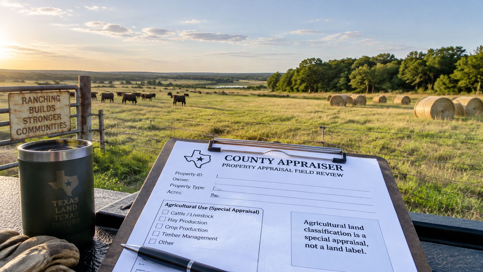
The Texas Comptroller's agricultural productivity appraisal guidance explains that 1-d-1 productivity appraisal depends on land being used for agriculture or timber, meeting the degree of intensity generally accepted in the local area, and having that use in at least five of the preceding seven years. The appraisal reflects the land's typical agricultural production capacity, rather than its open-market value.
Plain verdict: Current agricultural use and a qualifying history matter. Idle land or land recently converted to another use does not qualify automatically.
A sale, plat, or development proposal alone does not change how the acres are physically used. If construction or another activity removes only part of a tract from agricultural use, the change may affect those acres rather than the entire property. Owners can lose the tax benefit on land that stops meeting the use test, so the distinction between a plan and a physical change matters.
Ownership is not the only factor in eligibility. Corporations, partnerships, and investors may qualify based on the land's use and history; agriculture does not have to be their primary business for 1-d-1 appraisal. Texas tax classification is a use-and-history test, not an insurance or zoning category.
Apply through the county appraisal district, usually by May 1. The district reviews land use each year. Aerial photos may show grass or trees, but they cannot establish years of qualifying activity or whether local intensity standards are met. Records linking livestock, crops, hay, or timber work to particular acres help show what happened on the land over time.
Qualifying Uses and Ownership Rules
Texas has two agricultural categories, and confusing them is a common reason an owner files the wrong way or assumes they're ineligible. The table below puts them side by side before we talk about what counts as a qualifying use.
| Requirement | 1-d-1 Open-Space | 1-d Agricultural |
|---|---|---|
| Owner type | Any owner, including corporations and partnerships | Individual owner only |
| Primary income | Not required | Agriculture must be the owner's primary income source |
| Years of qualifying use | At least 5 of the previous 7 years | Generally at least 3 years |
| Intensity standard | Degree generally accepted in the local area | Land used for the qualifying agricultural purpose as the owner's primary occupation |
| What is appraised | Land and qualifying appurtenances | Land used for the qualifying agricultural purpose |
| Typical fit | Investors, companies and mixed-owner tracts | Individual farmers and ranchers |
The Texas Comptroller's agricultural and timber appraisal page confirms that 1-d-1 open-space appraisal requires land currently devoted principally to agricultural use, at the locally accepted degree of intensity, with agricultural or timber use for at least five of the preceding seven years. The narrower 1-d category instead requires an individual owner, agriculture as the owner's primary income source, and qualifying use for generally at least three years.
Most Austin area owners, investors, and family entities are really asking about 1-d-1. If land is held in a company or partnership, or if you earn most income elsewhere, 1-d is usually the wrong frame. That ownership flexibility under 1-d-1 is helpful, but it doesn't relax the use test one bit.
Uses That Can Qualify
Qualifying activity has to look like a working agricultural operation at a level local operators would recognize. Common examples include:
- Crop production: Cultivating soil and producing crops for sale or feed use, with planting, harvest, and sales or use records.
- Livestock and poultry: Raising cattle, goats, sheep, pigs, or poultry at stocking and management levels typical for the county.
- Dairy and aquaculture: Milk production or raising fish and other aquatic stock as an ongoing operation.
- Hay production: Cutting, baling, and selling or using hay on a recurring seasonal cycle.
- Timber production: Growing and harvesting timber under an active management or harvest plan.
- Apiculture: Beekeeping for honey or pollination, with hive counts and placement records that fit local guidance.
- Wildlife management: Documented habitat practices on land that moves from agricultural use into a qualifying wildlife plan, rather than leaving land alone.
No single item on that list qualifies by itself. The appraisal district asks whether the activity is principal, ongoing, and intense enough for the area. A crop that is planted once and abandoned, or bees placed briefly with no management record, doesn't carry the same weight as a documented annual operation.
Edge Cases That Trip Owners Up
A backyard garden, a few hobby horses, or two goats on a homestead parcel rarely meet the intensity test. The problem isn't that the animals or plants are the wrong kind. The problem is scale and purpose, because a working operator nearby would manage more acres, keep records, and produce something for market or ranch use.
Leased land can qualify, but only when the lessee's use is ongoing and documented. If your cousin runs cattle under a handshake deal and nobody can show dates, stocking, or acres covered, the district has little to approve. A written lease with acreage, term, and permitted agricultural use gives both parties a file they can defend.
Your house doesn't become agricultural just because the pasture qualifies. The classification covers the land and qualifying appurtenances, not ordinary homes and non qualifying improvements.
Barns and similar structures need the same careful treatment. Ask how the district treats each improvement instead of assuming the whole account moves to productivity value. Splitting the parcel mentally into homesite, improvements, and working acres prevents a surprise later.
Apply one test today: does the parcel show ongoing use at a level a working operator in the area would recognize? If you can't answer yes with dated evidence, improve the operation and the records before you rely on the lower value.
How Productivity Value Replaces Market Value
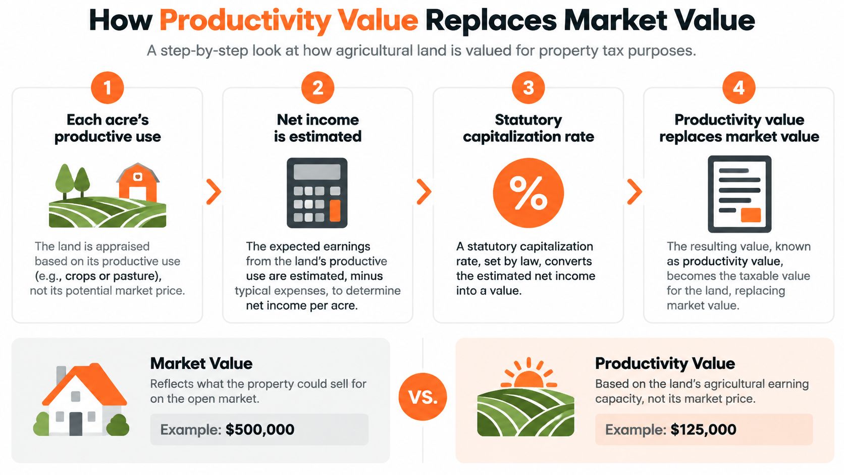
For qualifying acres, productivity value replaces market value for property tax appraisal. A statutory capitalization rate converts typical net income from the land into its productivity value. The result reflects the land's earning capacity, not what a buyer might pay for a homesite or development opportunity.
For 2026, the Texas Comptroller's capitalization rate page gives a 10.00% cap rate for agricultural or open-space land. Appraisal districts establish typical net income for each local land class using a five-year period ending two years before the appraisal year. That time lag smooths out unusually strong or weak years instead of letting one season set the value.
The Four Steps
Classify the land by productive use. The district assigns acres to local agricultural classes, such as native pasture, improved pasture, dry cropland, irrigated cropland, or timber types. Each class has its own typical income figure. Irrigated bottomland and rocky grazing land, for example, do not produce the same return.
Estimate typical net income to land. The district starts with typical income the land can generate and subtracts typical expenses, including property taxes, fencing, and irrigation-well costs. The remainder is net income to land, the return attributed to the land itself rather than to equipment, labor arrangements, or an unusually good year.
Divide by the statutory cap rate. This turns an annual income figure into a capital value. At a 10.00% rate, each $1 of annual net income supports $10 of productivity value. The calculation can therefore produce a low appraisal even where nearby sale prices are high.
Apply the productivity value per acre. The district assigns the resulting value to qualifying acres in that class. Tax appraisal follows that figure rather than the price a developer, neighbor, or homesite buyer might offer.
A 100 Acre Illustration You Can Recalculate
This hypothetical example uses the 2026 cap rate above. Replace the assumed income and expenses with your district's figures for the relevant land class, and the calculation works the same way.
| Step | Per Acre |
|---|---|
| Typical gross land income | $60 |
| Less expenses for taxes, fencing and well costs | $20 |
| Net income to land | $40 |
| Productivity value at 10.00% cap rate | $400 |
| Market value for comparison | $5,000 |
The calculation is $40 divided by 0.10, or $400 per acre. Across 100 acres, the example gives $40,000 of productivity value instead of $500,000 of market value at $5,000 an acre. For an explanation of how current agricultural use value works, compare the general method with the land-class schedule published by your district.
The gap can be especially wide where land sells for development but generates modest farming income. A parcel near a suburb may command a homesite price because of roads, schools, and utilities, even if its soil supports only modest grazing. Rural land may have a smaller gap when its market price is already closer to its ranch earning power.
Assumption check: Productivity value measures productive capacity, not resale potential. An estimate based on comparable land sales is a market-value estimate, not a productivity-value calculation.
Use typical income rather than a personal best year to understand the district's figure. The five-year window smooths strong and weak seasons, so current drought or high cattle prices may not immediately change the schedule. That lag makes the appraisal less responsive to short-term swings.
Typical Savings and Rollback Exposure
Take the same hypothetical 100 acre parcel and apply a clearly stated assumption you can change: a combined effective tax rate of 2.00%. At $500,000 of market value, annual tax is $10,000. At $40,000 of productivity value, annual tax is $800. The saving is roughly $9,200 a year.
That's the financial promise of agricultural land classification when the use is real. It's also why owners get careless about the other side of the ledger. The saving is not a permanent discount on land that later stops being agricultural. It's tied to continued qualifying use, acre by acre and year by year.
Why Savings Differ So Much by Parcel
Savings scale with the gap between market value and productivity value, not with acreage alone. A small tract inside or near a city may have a very high market value per acre, but if only a few acres qualify, the dollar saving may be modest. A larger ranch farther out may show a lower market price per acre yet save more total dollars because more acres move to a low productivity schedule.
Don't estimate your benefit from a neighbor's bill. You need three inputs for your parcel: qualifying acres, the district's productivity value for that land class, and the combined tax rate that applies to the account. Homesites and non qualifying improvements stay outside the agricultural calculation, so a ranch with a valuable house won't see its entire tax bill fall by the same percentage as the land value.
Owners usually lose money not because the annual saving was small, but because they never priced the exit. Price the rollback before you change the use, not after the new tax statement arrives.
How Rollback Works
When qualifying use ends through a change to a non qualifying use, the district recovers taxes you would have paid at market value. The Texas Comptroller's agricultural appraisal publication states that rollback generally requires an actual physical change in use, compares taxes paid under agricultural value with taxes that would have applied at market value for the prior three years, and notes that interest can also apply to certain 1-d properties.
Use the worked example again. If all 100 acres changed use after three years at those assumed values, the annual difference is $9,200, so three years sums to $27,600 before any interest that may apply. Your real number will differ because market values, productivity values, and tax rates change by year and by parcel, which is why the district recalculates each of the three years separately. For the mechanics and timing in more depth, review how rollback taxes work in Texas before you sign a development or sales contract that allocates that cost.
The Partial Change Most Owners Miss
Rollback follows the acres that physically change. If you convert 25 of the 100 acres to homesites while the other 75 acres continue grazing, rollback applies to the changed 25 acres, not automatically to the whole ranch. Under the same assumptions, the annual tax difference on those 25 acres is $2,300, and three years totals about $6,900 before interest.
The trigger surprises sellers in the other direction too. A plat, a sale, or a development plan by itself doesn't create a rollback event without an actual physical change in use. A buyer can purchase classified land and continue the agricultural operation. A developer can draw lots on paper while cattle still graze. Liability follows the physical conversion, such as building homesites, commercial use, or otherwise ending agricultural use on those acres.
That distinction matters in contracts around Austin, where land may be platted, optioned, and marketed long before dirt moves. Put in writing who bears rollback if conversion happens after closing, and map exactly which acres will change first. Keep a dated record of the year and month any change begins, with photos and contractor or utility records tied to the affected acres. When a dispute comes up, that timeline is often the difference between paying on part of a parcel and arguing over the whole thing.
Documentation and Evidence That Holds Up
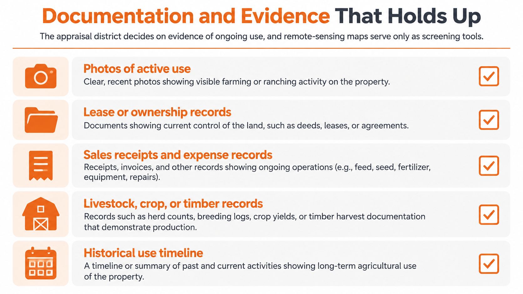
The appraisal district decides on evidence of ongoing use, and remote sensing maps serve only as screening tools. If your file can't show continuity, intensity, acreage, and management, a green field on an aerial photo won't save the classification.
Build the file before the district asks for it. These records work because each one proves a different element of the test, and together they show an operation rather than a one time activity.
- Lease agreements: Signed leases with dates, parties, acreage, and the agricultural use permitted, plus renewals that show continuity.
- Livestock records: Stocking counts, purchase and sale receipts, brand or ear tag records, feed invoices, and veterinary bills.
- Hay and crop records: Cutting dates, bale counts, custom baling invoices, seed and fertilizer receipts, and sale tickets.
- Timber records: A written management plan, forester reports, harvest contracts, scale tickets, and reforestation receipts.
- Operating receipts: Fencing, water wells, troughs, brush control, pasture seeding, and repairs that show active management of the land.
- Dated photos: Photos tied to specific fields or pastures across seasons and years, not a single undated set.
- Acreage map: A parcel map that separates homesite acres, non qualifying areas, and each agricultural land class.
- Prior filings: Previous applications, approvals, district correspondence, and any wildlife or timber plan updates.
Keep the map and the paperwork consistent with each other and with your Texas property tax records, because mismatched acreage is an easy reason for a reviewer to pause an approval. If a lease covers 80 acres but your map shades 100, explain the remaining 20 in writing.
What Imagery Can and Cannot Prove
The USDA National Agricultural Statistics Service Cropland Data Layer guidance reports 77.5% overall accuracy in its 2024 statewide crop-specific assessment across included agricultural classes, with major crop categories commonly achieving approximately 85% to 95% producer accuracy and corn reported at 92.6% producer accuracy, while some mixed crop classes perform substantially lower. Producer accuracy tells you how often real ground acreage in a class is captured on the map. It does not guarantee that a mapped pixel on your parcel is correctly labeled.
Errors come from crop rotation, fallow fields, mixed pixels, and vegetation that looks similar from above. Grazed pasture can resemble idle grass. A field resting between crops can look abandoned. A small plot below the mapping resolution can disappear entirely.
Treat any imagery result as a starting point, then validate it against parcel boundaries, current management records, historical imagery, and ground evidence.
If an automated or aerial read gets your land wrong, respond with correction rather than argument. Identify the acres in dispute on your map, supply the dated records for those acres, and request a review tied to the specific years questioned. A calm, documented correction gives the district something it can approve.
County-Specific Considerations and Case Studies
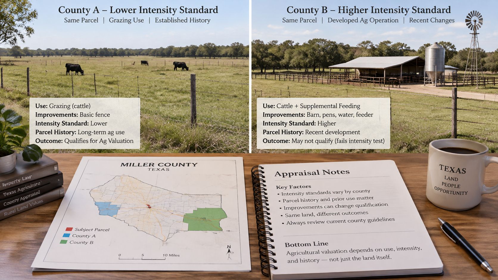
The same use can produce different outcomes depending on the county, the appraisal district's intensity standards, and the parcel's own history. Texas law supplies the framework, but your district sets local land classes, typical net income schedules, and the evidence routine you'll face.
That local layer matters more than any statewide checklist. Native pasture expectations in one county reflect its rainfall, soils, and normal stocking practice. Timber expectations in East Texas reflect a different industry altogether. An operation that looks solid in one district may be light in another where operators customarily run more animal units per acre or cut hay more often.
What Changes From County to County
- Intensity norms: Ask how the district describes the degree of intensity generally accepted in the area for your use, whether that's stocking, crop practice, hive density, or timber management.
- Land class income figures: Typical net income per acre is local, so productivity values for the same broad use differ across districts.
- Evidence practice: Districts vary in how they request records, schedule field reviews, and handle leased or mixed use parcels.
- Partial conversion handling: Fast growing counties deal with platted but still grazed acres more often, and their paperwork may ask for clearer acreage splits.
Ask your appraisal district for its agricultural appraisal guidance before you file. That one request tells you the standard you'll be judged against and stops you from copying a neighbor county's approach. In Austin and Travis County, development pressure makes the partial use question routine, because owners often sell, plat, or phase a project while part of the land is still being worked.
Four Illustrative Parcels
The outcomes below are illustrative, not predictions. Your district reviews your actual acres, history, and records, and small factual differences can move the result.
| Case | Parcel Facts | Likely Outcome |
|---|---|---|
| 10-acre hobby ranch near Austin | A few goats and some hay, with no sales or feed records | Weak file; intensity test likely unmet without records |
| 120-acre family ranch | Leased cattle under a written lease, annual hay cutting, stocking, feed and sale records kept by year | Stronger file; leased use is documented and recurring, subject to the local intensity standard |
| 200-acre tract with 40 acres platted | 40 acres platted for homes, remaining acres grazed | Grazed acres likely qualify; platting alone does not trigger rollback, but a physical change on the 40 acres would trigger rollback on those acres only |
| Leased East Texas timber tract | Written harvest plan, reforestation receipts and timber invoices | Strong file; confirm the local timber intensity standard |
The Austin hobby ranch fails on proof, not on land quality. Even if the goats are real, the owner can't show intensity, sales, feed purchases, or a consistent operation a local rancher would recognize. Adding animals for one season won't repair the history requirement, and claiming the whole homesite parcel invites a denial that could have been avoided with a smaller, honest acreage claim and a real operating plan.
The 120 acre family ranch shows why leasing isn't a weakness when it's documented. The lessee's cattle, the annual hay work, and the dated records all point the same direction. The district still checks stocking and management against local norms, but it has a coherent file to approve.
The 200 acre tract is the case owners get backwards most often. They fear the plat itself will trigger a large rollback bill, even while grazing continues, or they assume a sale cleans the slate. Neither assumption is reliable. The financial clock runs when physical use changes, and it runs on the changed acres, so the map of which 40 acres convert first is a tax document, not just a survey detail.
The timber tract wins on professional documentation. A harvest plan and reforestation receipts show intentional production across years, which is exactly the continuity timber classification needs because trees don't produce an annual harvest receipt.
Local standards and records decide the result as much as the acreage does.
If you take one lesson into a county office, take that one. Bring the local guidance, your acreage map, and records organized by year. You'll spend the meeting answering specific questions instead of defending a general claim that the land looks agricultural.
Confirm Your Eligibility Before You File
Before submitting an application, check that the parcel's history, current use, and acreage map tell the same story. A parcel can be sold, platted, or included in a development plan without those steps alone triggering rollback. The financial clock is tied to a change in physical use, and liability can apply only to the acres that changed.
- Confirm the history. Document qualifying use for at least five of the last seven years for 1-d-1, or generally three years for a 1-d individual owner.
- Check local intensity. Ask the appraisal district for its agricultural appraisal guidance and the accepted degree of intensity for your type of use.
- Organize dated records. Group leases, production and sales receipts, management plans, photographs, and acreage maps by year and by acres.
- Map any change. Mark acres that have physically changed use separately from those still in agricultural use. A plat or listing alone does not establish that physical change has occurred.
- Meet the deadline. File by the district deadline, usually May 1, and keep proof of submission.
- Keep an annual record. Note continued use each year and date when a physical change in use begins.
If one part of the file is weak, address that part rather than making a broad claim for every acre. A narrower, well-documented application can distinguish eligible land from acres whose use has changed. INTELLI applies a data-driven system to organize the evidence file and check whether a parcel qualifies before a filing is made.
Before filing, be ready to identify three facts: the parcel, its qualifying use, and the year any physical change began. Records for each help clarify which acres may qualify and where rollback exposure may arise.
If your acreage, history, or partial conversion is unclear, have the file reviewed before filing or changing the use. Visit INTELLI to have your Texas parcel reviewed for agricultural classification, productivity value, and rollback exposure, with the evidence organized around your land class and county standard.